Malvern U3A Field Excursion to Pembrokeshire
Whitesand Bay and St David’s Head - Saturday 8th October 2011
Geological Itinerary (Numbered locations are shown on the route maps.)
Whitesand Bay
Walk from car park to far end of the beach (roughly 700m)
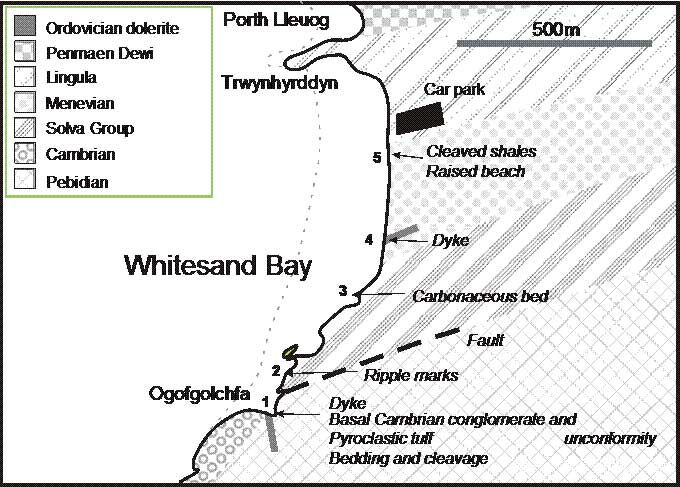
1 At Ogofgolchfa, inspect
Precambrian tuff (bedding/cleavage; ignimbrite structure),
Cambrian conglomerate (unconformity; imbrication and evidence for flow direction)
Ordovician intrusion (dolerite)
Return, slowly, to car park, inspecting on the way :
2, 3 Structures in Cambrian sandstone, including ripple marks and carbonaceous bed
4 Another Ordovician dolerite intrusion
5 Cleaved Ordovician shales
5 Quaternary raised beach deposits
St David’s Cathedral
Inspect the building stones of the cathedral; Caerbwdi sandstone, Precambrian tuffs
St David’s Head
Walk from Whitesand Bay car park to St David’s Head (roughly 1800m)
On the way :
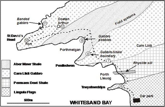
6 Lingula Flags at Trwynhwrddyn; Rhyolite sill at Porth Lleuog.
7 View over the St David’s area - General geology and geomorphology of the area
8 Carn Llidi gabbro and its boundary with overlying Aber Mawr shale
8 Carn Llidi and St David’s Head as a Caledonian syncline
9 Pebbles at Porthmelgan
10 Iron Age fort on St David’s Head
11 Banded gabbro in the cliffs
12 Coetan Arthur megalithic burial chamber
Return to car park
Solva (a possible short visit on the way to Tenby)
A ria (flooded Quaternary valley)
Summary of Geological History (See more detailed account on the following pages) –
Precambrian : Subduction to the north-west of Pembs gives rise to volcanic activity.
Cambrian : Forces due to oblique subduction generate major north-east to south-west faults. Subsidence on these faults results in the formation of the Welsh Basin. The basin fills gradually.
Ordovician : Renewed subduction gives strong volcanism in north Pembs. Avalonia separates from Gondwana and drifts north.
Devonian : Avalonia collides with Laurentia. Folding and cleavage of north Pembs rocks. (Caledonian Orogeny)
Late Carboniferous : Armorica and Iberia collide with Avalonia. Folding of south Pembs rocks (Variscan Orogeny).
Geological History for Whitesand Bay visit
(Numbers in brackets refer to location numbers in the geological itinerary and the route maps.)
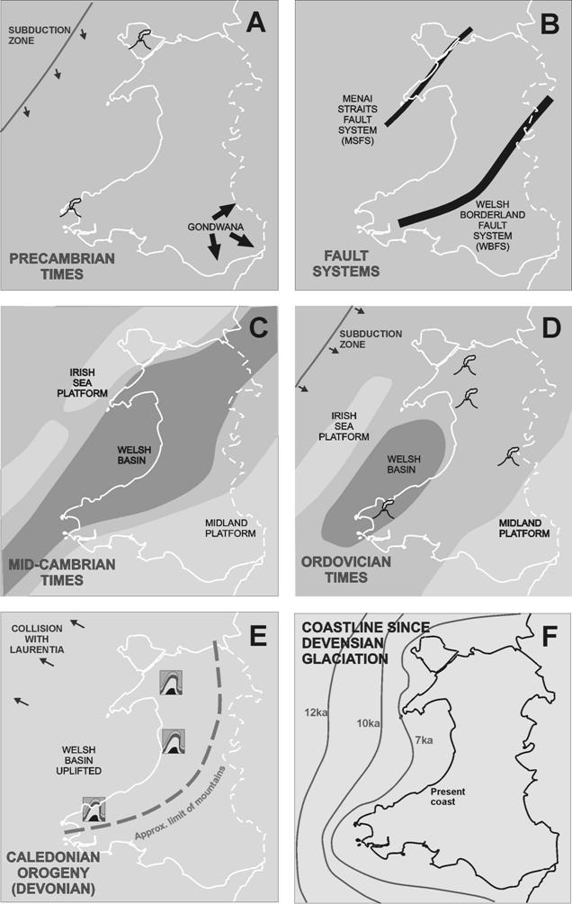
(Letters in brackets refer to the palaeogeographical maps on the last page of this document.)
In the late Precambrian period (A), around 700 million years ago (700Ma) the area of crust that is now England and Wales lay on the edge of the southern supercontinent of Gondwana at a latitude of about 60° south and probably under the sea. It was bordered to the north-west by a subducting oceanic plate (at roughly the location of the present Irish Sea). The subduction generated volcanic activity and an island arc was formed, much as in the case of Japan today. Associated with this was the generation of plutonic igneous rocks (diorite, etc.) and volcanic ashes and lavas. All of these types of rock are exposed in Pembrokeshire, the volcanic rocks in the north near St David’s and the diorite (dated at 643Ma) in the south near Johnston, where it is quarried. We shall see examples of the Precambrian volcanic rocks (tuffs, including ignimbrite) at Whitesand Bay (1) and in the walls of St David’s cathedral. (The diorite has been used in sea-defence work at Tenby, as we shall see on Monday.) The erupting sediments eventually created shallow marine environments and then land.
The crustal collision causing the subduction was oblique and this later led to the generation of major parallel faults running north-east to south-west across what is now Wales and into the Marches (B). These lines of weakness, principally the Welsh Borderland Fault System (WBFS) and the Menai Straits Fault System (MSFS), have played a major part in the geological development of Wales and the Marches ever since. Although it is somewhat different in direction, it is likely that the crustal weakness which gave rise to the East Malvern Fault also originated at this time. Movement on the faults is thought to have produced a mountainous terrain which gradually eroded to a relatively flat surface.
By early Cambrian times, about 540Ma, the subduction had shifted to SE Ireland and gradually came to a halt. Volcanic activity likewise stopped and a stable, flat landscape ensued. Later, crustal extension occurred in the region behind the line of volcanic activity. The extension of the crust caused the subsidence of some regions between the fault systems. In particular, the region between the WBFS and MSFS gradually subsided to form a deep basin, the Welsh Basin (C). It contained most of Pembrokeshire and became a major factor in the geology of Wales up to Silurian times.
The Welsh Basin subsided gradually, over a long period, and simultaneously filled with a great thickness of sediments derived mostly from the land or shallower sea on its edges to the north-west and south-east. Thus, the local Cambrian rocks, some of which we shall see at Whitesand Bay (1‑3), commence with a conglomerate, laid down on the eroded Precambrian surface. This is followed by rocks formed in progressively deeper seas, initially near-shore sandstones and, later, deeper-water mudstones. They include a purple sandstone (Caerbwdi Sandstone) much used in the walls of St David’s cathedral. Shallowing in the basin occurred at the end of the Cambrian when the sediment deposition in the basin overtook the subsidence.
In early Ordovician times (490Ma), subduction NW of this area recommenced, leading to a great increase in volcanic activity locally (D). A little later, small sections of crust (tectonic plates) separated from mainland Gondwana and began to drift northwards. One of these, known as Eastern Avalonia, carried what is now the area of England, Wales, northern France and southeast Ireland. Meanwhile, thick layers of mud were deposited in the deepening Welsh Basin.
The main centres of the Ordovician volcanism locally are believed to have been in Ramsey Island and in the Fishguard area. The volcanism was violent in north Pembrokeshire, with explosive eruptions and lava emission, mostly under water. The sedimentary mudstones were intruded by sills and plutons. We shall see a couple of Ordovician dolerite intrusions at Whitesand Bay (1, 4). In the afternoon, we shall see the remains of a major pluton; a large quantity of magma intruded into the mudstone, solidified as gabbro and now exposed in the rocks of Carn Llidi (8, 9) and St David’s Head (12). Just north of Whitesand, in Porth Lleuog (6), a sill of rhyolite is prominent. A further intrusion, into Cambrian rocks, is seen on the harbourside at Solva. A crag of rhyolite at Roch, spectacularly topped by a small castle, is also Ordovician in age.
The northward drift of Eastern Avalonia resulted some 60 million years later, in the early Devonian, in its collision with the large continent known as Laurentia (thereby joining England permanently to Scotland). A mountain building episode resulted, known as the Caledonian Orogeny (E). The existing rocks of north Pembrokeshire were distorted and crushed in a north-west to south-east direction. This led to folding of the rocks. The intrusion at Carn Llidi and St David’s Head (8) shows a major example of this, being folded into a sharp syncline. The resulting ENE to WSW ‘grain’ of the country is evident from the geological maps. In addition, the pressure induced a widespread cleavage, especially in the Ordovician mudstones of the Welsh Basin, and we shall see examples on St David’s Head (8) and in the volcanic rock at Whitesand Bay (1).
No rocks of Silurian or Devonian age are found in north Pembrokeshire. Carboniferous rocks form the coast at Newgale, faulted against Cambrian sandstones, and thin coal seams may be found there.
The underlying geological structure of Pembrokeshire is quite complex but this is not generally reflected in the shape of the land surface, which is rather subdued apart from the Preseli Hills. The county is, like much of Wales, a series of wave-cut plateaux incised by later erosion. They are believed to be of Tertiary and Pliocene age. The plateaux are most clearly seen at the coast. For instance, the area around St David’s (7) is at a fairly uniform height of roughly 60m, broken only where some more resistant rock outcrops remain. The most evident of these outcrops is Carn Llidi, but small crags appear close to St David’s (e.g. Clegyr Boia). A younger and lower erosion surface is seen at Whitesand Bay (5), covered with Quaternary (Ice Age) deposits.
During the Ice Age, north Pembrokeshire was ice-covered at least twice, in the Anglian (about 450000 years before the present (BP)) and then the Devensian glaciations (until 10000 years BP). The Devensian ice occupied only the west and north of the county whereas the earlier Anglian glaciation extended as far south as the north Cornish coast. A variety of successive superficial deposits resulted from this. At Whitesand Bay (5), a raised beach (of pre-Devensian age), with large pebbles, rests on the old wave-cut platform in Cambrian shales. Above this are, successively, an early Devensian periglacial deposit of local rocks (Head), then Irish Sea Till, with far-travelled rocks, and a further Head deposit. This is capped by wind-blown sand.
Following the Ice Age, sea level rose dramatically due to melting of the ice cap, drowning many coastal valleys that had earlier eroded down to levels matching the 100m-lower sea level. The results of this show clearly around the coast of Pembrokeshire, most famously in Milford Haven. The harbour at Solva is in a deep valley cut by glacial meltwater, which is rapidly filling with sediment. At Newgale, the flat ground behind the storm beach shows the near completion of this process.
Newgale storm beach is composed largely of glacial debris brought from the Irish Sea area. Offshore, the remains of an ancient forest are sometimes seen at very low tides.